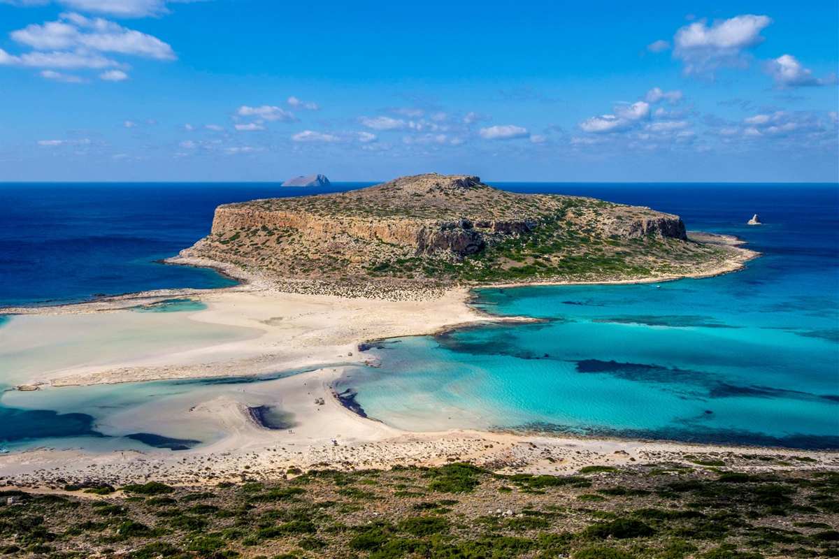
A Balos and Gramvousa catamaran trip sails out of Kissamos in the far north-western corner of Crete, past a fortress island to a shallow lagoon with pink-tinged sand. Our other tours in Greece cover the rest of the holiday.
Read on for the inclusions, the sailing time and departure port, the road transfer from Chania or Rethymno, the case for a catamaran, the island of Gramvousa and its Venetian fortress, the Balos lagoon and its pink sand, swimming and walking at Balos, the protected peninsula, the port town of Kissamos, clothes and kit, wind and sea conditions and the questions travellers ask.
What does a Balos and Gramvousa catamaran trip include?
A Balos and Gramvousa catamaran trip starts at Kissamos and calls at Balos Lagoon and Gramvousa Island. On one operator’s semi-private boat, one ticket covers the cruise and the meals. The same ticket adds water activities, an open bar and a hotel transfer.
Food and drink fill the day on a Balos and Gramvousa catamaran trip of this kind. Guests get a breakfast bowl, Cretan appetizers, an organic lunch and seasonal fruit. Coffee, tea, water and soft drinks are served, and the open bar adds local white wine and Greek beer.
The gear is part of the ticket too. The boat carries SUP boards, snorkelling equipment, swimming jackets and inflatable toys. An English-speaking crew looks after the guests, and sunbeds and shaded lounges sit on deck. Music, Wi-Fi, an onboard toilet and a shower are on board as well.
Guests do not only watch the sights from the water. This Balos and Gramvousa catamaran trip takes them ashore at both stops. At Balos Lagoon they swim, snorkel or paddleboard. At Gramvousa they explore the wild landscape and the Venetian fortress. Food, pace and swim stops can be adapted for children on request.
Packages are not the same on every boat. A daily boat from another operator keeps its bar open all day for breakfast, snacks and lunch. Lunch is not in that ticket. The same catamaran operator sells shared and private formats of the route, so the package follows the format.
Before you pick a Balos and Gramvousa catamaran trip, read the listing for meals, drinks and the transfer. The trip featured on this page names meals, drinks and a transfer in its title. Those three items come with that booking.
How long is the trip, and where does the catamaran leave?
A Balos and Gramvousa catamaran trip on one operator’s semi-private boat takes 7 hours. It leaves Kissamos Port at 8:30 in the morning and is back around 3:30 in the afternoon.
This Balos and Gramvousa catamaran trip follows a set order. The boat reaches Balos at about 10 in the morning and Gramvousa at about noon. A maximum of 22 guests keeps the group small.
Kissamos Port is the starting point of the Balos and Gramvousa catamaran trip in these listings. If you come to the port without a transfer, arrive 20 minutes early. The port check-in asks for a passport or ID.
Other boats keep other hours. A daily boat from another operator leaves Kissamos at 10:50 in the morning and sails to Gramvousa first. It arrives there at 11:50 and leaves at 1:30 in the afternoon. It reaches Balos at 1:45, and its stop there runs until 4:45. It docks in Kissamos at 6 in the evening.
So the stop order changes with the operator. The semi-private catamaran visits Balos first, and that daily boat visits Gramvousa first. Compare any Balos and Gramvousa catamaran trip on three points. Check the stop order, the hours at each stop and the return time.
From departure to return, the daily boat’s day lasts 7 hours 10 minutes. The catamaran’s day lasts 7 hours. The sail is a small part of that time. One operator calls its route an hour-long boat trip from Kissamos to Gramvousa and Balos. Another puts the port just 10 miles from Balos.
How does the transfer from Chania or Rethymno work?
The Balos and Gramvousa catamaran trip leaves from the port of Kissamos, about 41 kilometres from Chania. Travellers from Chania or Rethymno either join an operator’s hotel pickup or reach the port by car, bus or taxi.
One operator gives the drive from Chania as 45 to 50 minutes. A travel wiki says the Chania-Kissamos national road takes less than an hour. That operator names three ways to reach the port: drive, bus or taxi.
A Balos and Gramvousa catamaran trip from Rethymno needs more road time than one from Chania. Venetian conquerors picked Rethymno as an intermediate commercial station, placing it between Heraklion and Chania. That operator says journeys from Rethymno, Heraklion or Agios Nikolaos take a little longer.
Buses serve the port too. The wiki says a bus leaves Chania roughly hourly. The first runs at 6:30 in the morning, the last at 8:30 in the evening. The first operator names the early bus at 8.30 from Chania Central Station for its boat. That ride lasts around ninety minutes.
A second operator builds a hotel transfer into its Balos and Gramvousa catamaran trip. The transfer covers every region from Georgioupoli to Kissamos. Its list names Platanias, Chania town, Kolymbari and Falassarna. Pickups run from 6:30 to 7:30 in the morning, with the exact time set by the area.
Rethymno is not in that list, so ask the operator whether a hotel there is covered. Drivers find a car park in front of the port. Side roads close by also take cars.
For a Balos and Gramvousa catamaran trip, the first operator asks guests to arrive half an hour before departure. The second operator asks for 20 minutes when guests come without its transfer.
Why do operators use a catamaran on this route?
A catamaran rides on a pair of equal hulls set next to each other. A wide gap between them gives stability. A Balos and Gramvousa catamaran trip uses that steady deck for sunbeds, shaded lounges and swimming stops.
An encyclopedia entry explains the design. Hulls set far apart hold the boat steady against rolling and capsizing, and builders add no ballast. Its draft is shallower than that of a single-hull boat of equal length.
The design also saves effort. A pair of hulls can push through the sea with less drag than one comparable hull. Sails or motors then work less. The wide stance can also cut wave motion and leave a smaller wake.
One operator’s semi-private Balos and Gramvousa catamaran trip limits the boat to 22 guests. Its listing names sunbeds, shaded lounges, an onboard toilet and a shower. At Balos, a tender takes guests close to the beach.
A travel blog describes the deck of a boat on a Balos and Gramvousa catamaran trip. It has built-in seats at the front, shaded spots at the back, a sun deck above and trampoline netting.
Tamil gave the name: kattumaram, which means logs bound together. English later applied it to twin-hulled vessels. Austronesian peoples invented the catamaran, and it let them spread to islands of the Indian and Pacific Oceans. The same idea now carries guests on a Balos and Gramvousa catamaran trip.
What is Gramvousa, and what lies on the island?
Gramvousa is the name of two small, uninhabited islands off north-western Crete, in the Chania regional unit. A Balos and Gramvousa catamaran trip visits Imeri Gramvousa, the island that carries a Venetian fort.
In Greek, Imeri Gramvousa means Tame Gramvousa. It is the island where the boat stops on a Balos and Gramvousa catamaran trip. Its twin, Agria Gramvousa, is the Wild Gramvousa. Agria sits straight north of Imeri and is far less welcoming. A third name for it is False Gramvousa.
Ruins on Imeri Gramvousa come from two groups of people. Venice left a fort. Cretan insurgents left the remains of their buildings. They were forced to live as pirates in the Greek War of Independence. Today the island draws tourists, and a Balos and Gramvousa catamaran trip from Kissamos can include it.
Old names add colour. Korykos, the ancient name of the larger island, means leather bag. Other names for Gramvousa include Grampousa, Cavo Buso, Garabusa and Grabusa. The name honours Vousa, who was married to a pirate chief. Of all who lived there, only she evaded capture as the pirates were removed by force.
One operator describes the island as a wild landscape with a Venetian fortress perched high above the sea. One public photo shows the view of the Balos lagoon from that fort. The municipality of Kissamos administers both Gramvousa islands, and nobody lives on either of them.
What is the Venetian fortress on Imeri Gramvousa, and how do you reach it?
Venice built the fortress on Imeri Gramvousa in the late sixteenth century. Venice meant it as a defence of Crete against the Ottoman Turks. On a Balos and Gramvousa catamaran trip, you reach it on foot.
After you land from a Balos and Gramvousa catamaran trip, a path leads up to the fortress. One operator’s timeline gives two choices on the island: swim, or walk up to the fortress. A second operator names the view of the area from the fort and a quick swim on the small beach.
The fort that a Balos and Gramvousa catamaran trip visits stayed Venetian throughout the long Cretan War. In the late seventeenth century, a treaty handed Crete to the Ottomans. Venice still kept Gramvousa, with the forts of Souda and Spinalonga. All three guarded Venetian trade routes. Late in that same century, the commander betrayed the fort to the Ottomans.
The Greek War of Independence brought a band of Cretans home from battles in the Peloponnese. Dimitrios Kallergis and Emmanouil Antoniadis commanded the band. They dressed as Turks and captured the fort, which became their base. The Ottomans never won it back. The success revived the Cretan uprising and began the so-called Gramvousa period.
The fighters lived under siege for over two years, survived by piracy, and built a school and a church. Later, the new governor of Greece sent British and French ships. They wiped out the pirate fleet, and the fort passed to British control. Today a Balos and Gramvousa catamaran trip offers a walk up to that same fort.
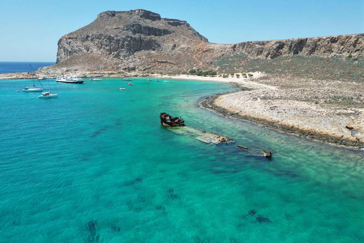
What is the Balos lagoon, and why does the sand look pink?
The Balos lagoon is a shallow bay where the Gramvousa peninsula ends in the north-west. Its sand looks pink because of millions of crushed shells. The catamaran drops anchor here for swimming on a Balos and Gramvousa catamaran trip.
The lagoon that a Balos and Gramvousa catamaran trip visits lies between Gramvousa island and the Cretan shore. A local Greek page puts it about 17 kilometres north-west of Kissamos, between Cape Gramvousa and Tigani. Its south-west side opens to the sea.
A Cretan beach site says the sand has a pinkish tint in places, because of millions of crushed shells. A hiking site sets turquoise water against pinkish white sand. A local Greek page calls the sand white with pink tones and the water blue-green. On a Balos and Gramvousa catamaran trip, study these colours from the anchored boat.
Tigani is a small rocky peninsula, joined to the main part of Crete by a narrow neck of land. Its name means frying pan in Greek. The Cretan beach site also mentions a little chapel of Saint George there.
Ruins of Agnion stand at the Korykon cape, north of the bay. This ancient Roman town was small and had a temple for the god Apollo. A Balos and Gramvousa catamaran trip reaches the bay by water, not by the dirt road from Kaliviani.
How do you swim and walk at Balos?
You swim in the shallow, warm water of the lagoon and walk through it barefoot. A Balos and Gramvousa catamaran trip brings you to the bay by boat, so the lagoon is your swim stop.
On one operator’s Balos and Gramvousa catamaran trip, a tender runs close to the beach. Guests swim, snorkel or paddleboard in shallow turquoise water. The Cretan beach site calls the sea very shallow and warm, ideal for young children. The local Greek page adds that the beach is deeper on its open side.
Past the rocks that mark the lagoon’s boundary, the sea turns deeper and colder, which suits snorkelling. Another operator names the north side of the lagoon, facing Gramvousa island, for swimming in turquoise water. Choose your spot on a Balos and Gramvousa catamaran trip by the depth you like.
A hiking site describes the walk inside the lagoon. You cross the shallow, crystal-clear water barefoot. That way you move between the different areas of the lagoon. You also reach the sandy strip that keeps the lagoon apart from the open sea.
Road visitors walk instead. A marked, wide, stony path leads down from the dirt car park in natural steps. The hiking site says it holds no particular difficulties. It gives about 20 minutes to the sandy basin and warns of slippery ground. Where a tender runs, a Balos and Gramvousa catamaran trip replaces that walk with a boat ride.
The path passes a vantage point with wooden balustrades. From there the lagoon, Tigani and Gramvousa island come into view. The climb back follows the same route, and the hiking site suggests the cooler hours.
What is the Gramvousa peninsula, and why is it protected?
In north-western Crete, the peninsula called Gramvousa makes up the west side of Kissamos Bay. Balos and Gramvousa both belong to the Natura network of protected areas. That makes every Balos and Gramvousa catamaran trip a visit to a protected nature area.
Two pairs of peninsulas reach into the sea from north-western Crete. Gramvousa makes up the western pair, and Rodopos makes up the other. Two small islands lie off the Gramvousa coast. The Balos lagoon sits in the same area, so a Balos and Gramvousa catamaran trip visits both.
Natura is a network of protected areas. One travel page calls it the largest such network on the planet. It adds that the network shelters species and habitats that Europe protects and values. A Balos and Gramvousa catamaran trip from Kissamos Port sails along the Gramvousa peninsula. The boat passes that protected shore.
A Balos and Gramvousa catamaran trip passes a coast with a long list of wildlife. One travel article says Gramvousa holds 400 different plants, sea plants included, and almost 100 protected or endangered bird species. It also names the Mediterranean monk seal. Another page calls Balos a natural habitat with rare flora and fauna.
The plant article adds that Imeri Gramvousa and Balos beach have no place to buy food or drink. One page lists Eleonora’s falcons among the birds on the beach. North of Balos, on Cape Korykon, a small Roman city called Agnion once stood. Its ruins include a temple to Apollo.
What is Kissamos, the port town of the trip?
Kissamos is a western Cretan town and municipality that belongs to the Chania regional unit. It is now a port and fishing harbour. One operator sails its Balos and Gramvousa catamaran trip from Kissamos Port.
People also call the town Kastelli, a name that comes from the Venetian castle once there. A traveller bound for a Balos and Gramvousa catamaran trip can arrive by sea. A regular ferry links the harbour with the Peloponnese via Kythira. A census counts 10,632 people in the whole municipality.
The harbour behind a Balos and Gramvousa catamaran trip has ancient roots. Strabo placed ancient Cisamus under Aptera and named it that city’s naval arsenal. Archaeologists have found mosaics in the town, left by the Roman city of Kisamos. The old palace of the Venetian governor now holds a town museum.
Ancient Cisamus became a Christian bishopric, and the Orthodox bishopric still exists. Venice took Crete in the early thirteenth century, and Kissamos then became a Latin Church diocese. The names of more than 20 Latin bishops are known from then to the end of the sixteenth century.
Three former municipalities, Inachori, Kissamos and Mythimna, joined to form the municipality. In the north-west, its Kissamos unit holds the Gramvousa peninsula, with villages such as Sfinari and Platanos. The municipality also administers the Gramvousa islands. A Balos and Gramvousa catamaran trip from Kissamos Port reaches islands run by the same municipality.
What do you wear and bring on a Balos and Gramvousa catamaran trip?
Take a hat, a towel and sunscreen, and dress in swimwear and comfortable shoes. One operator lists the towel, sunscreen, hat and swimwear for its Balos and Gramvousa catamaran trip. It requires a passport or ID at port check-in.
Comfortable shoes come from a second operator’s notes. It tells passengers to wear a hat, sunscreen and comfortable shoes, and says summer temperatures can be really high. Its stop on Gramvousa offers a path up to the Venetian fortress, or a quick swim at a small beach. That path is where good shoes help.
Plan for strong sun. A travel wiki describes Chania from April to October as dry and hot, under clear skies. An encyclopedia sorts the island’s weather mainly as hot-summer Mediterranean. On a Balos and Gramvousa catamaran trip you are outdoors all day, so the hat and sunscreen matter.
Bring water for the shore. The second operator writes that there is no fresh drinking water on Balos or Gramvousa. Its boat keeps a bar open all day. The bar sells bottled water, snacks and lunch, and cards are accepted on board.
Tours differ in what they hand out. Read the listing for your Balos and Gramvousa catamaran trip before you buy extra food or drinks. The first operator adds that towels and sunscreen are yours to bring, along with the passport or ID.


When is the sea calm, and when are the boats held back by wind?
Cruises to Gramvousa and Balos run from late spring through October, depending on the weather. The captain is free to alter the route when wind or sea conditions call for it. The wind to watch on a Balos and Gramvousa catamaran trip is the meltemi, a dry northern wind.
The operator pages name no calm month for a Balos and Gramvousa catamaran trip. The season is wide, and the weather settles each sailing, not the calendar.
An encyclopedia names the meltemi, or Etesian wind, as a dry northerly that returns each summer. It arrives in late spring and fades around mid-September. Gusts peak in the afternoon. At night the wind can settle, and now and then it blows for days in a row. Around Crete it comes from the north-west.
It builds in clear weather with no warning. Its top strength is force 7 or 8, measured on the Beaufort scale. Certain yachts and certain ferries between islands cannot sail in such conditions. A bright sky at breakfast says little about the wind at lunch.
Operators plan around this. One cruise page says safety comes first and the order or the stops can change. Another operator follows the weather report and the Coast Guard instructions. Read the route listed for your Balos and Gramvousa catamaran trip as a plan, not a promise.
A travel wiki credits that northern breeze with cooling the dry, hot days around Chania. The wind is welcome on a hot day. On a strong day it is also the reason a captain reshapes a Balos and Gramvousa catamaran trip.
What else do travellers ask about a Balos and Gramvousa catamaran trip?
How large is Crete, where a Balos and Gramvousa catamaran trip runs?
Crete is the biggest island of Greece, with the biggest population too. It covers 8,450 square kilometres, and the shoreline runs for 1,046 kilometres. From west to east it measures 260 kilometres, yet it is narrow from north to south. In the Mediterranean Sea, only Sicily, Sardinia, Cyprus and Corsica are bigger.
Which seas lie around Crete?
Crete forms the southern border of the Aegean Sea. To its north is the Sea of Crete, which has a second name, the North Cretan Sea. On the south coast you find the Libyan Sea, known as well as the South Cretan Sea. The north-western corner holds the stops of a Balos and Gramvousa catamaran trip.
Which airport suits a Balos and Gramvousa catamaran trip?
Two airports on Crete serve international travellers. One is the Nikos Kazantzakis airport at Heraklion, and the other is the Daskalogiannis airport at Chania. Heraklion is 145 kilometres east of Chania. The Chania airport carries the name of Daskalogiannis, a renowned Cretan rebel from the Ottoman era.
What is Chania, the city of the region?
Chania stands along the north-west shore of Crete. The regional unit that carries the city’s name has Chania as its capital. That unit holds the Gramvousa islands, the island stop of a Balos and Gramvousa catamaran trip. The municipality counts 111,375 inhabitants. Besides the city itself, it includes nearby areas such as Souda, Galatas and Aroni.
A Minoan settlement once stood here, and Linear B tablets from Knossos call it Ku-do-ni-ja. The later Greek town was named Cydonia, and the English word quince comes from that name. The time zone of Chania is UTC+2. Summer time moves the clocks to UTC+3.
Which mountains rise on Crete?
Crete is mostly mountainous. One mountain range runs across the island, west to east. Its highest point is Mount Ida, also called Psiloritis, at 2,456 metres.
Thirty summits of the White Mountains, known as Lefka Ori, stand higher than 2,000 metres. Crete also has the Samaria Gorge, a World Biosphere Reserve. In Greek myth, Crete is the birthplace of the god Zeus.