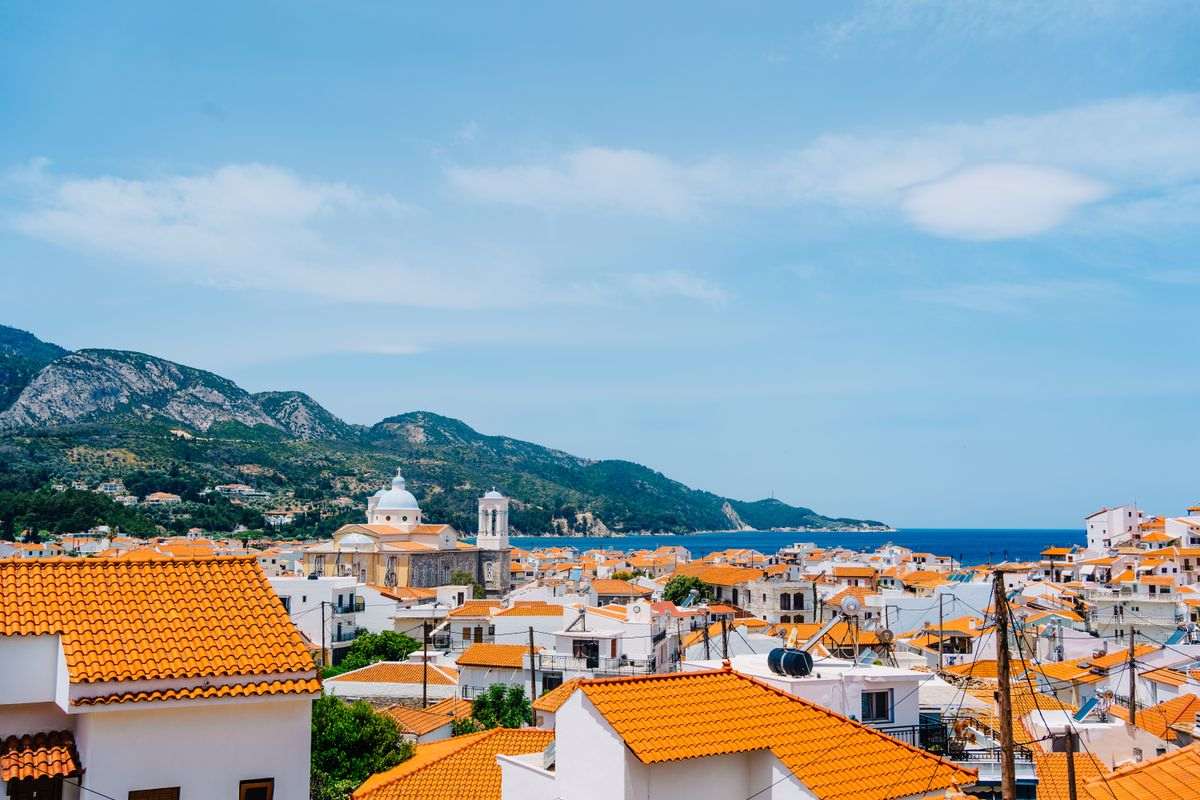
Samos tours take travellers to a North Aegean island close to the Turkish coast, with the ancient harbour town of Pythagoreion at its south-eastern end. For other routes, see our tours in Greece page.
This page covers what Samos tours include, how the island is reached by air and sea, the Heraion and the Tunnel of Eupalinos, the beaches, the villages and Mount Kerkis, the neighbouring islands and Ephesus, and the questions travellers ask.
What do Samos tours include?
Samos tours cover visits to ancient sites, village hikes, boat trips and wine tastings. Day trips to nearby islands and Turkey are part of the offer. Local operators run them from Samos itself, and listings group them by length.
Samos is a Greek island off the coast of western Turkey. Chios lies to its north, while Patmos and the Dodecanese lie to its south. Wikipedia says a strait named Mycale divides it from the Turkish shore, at 1.6 kilometres across. The island is 43 kilometres long and 13 wide, covering 477 square kilometres.
Samos tours on land include an island tour. One listing describes it as a visit to the Heraion sanctuary and the village of Potami. Another listing offers a day hike through Nightingale Valley to Manolates. A farm tour with carob tasting appears on a third listing page. Our Samos photo gallery shows more of the island.
One listing of Samos excursions sorts them by length. Wine tastings and an evening tour of the villages take two to four hours. Island tours, the hike and boat cruises take four to eight hours. That group includes an east coast cruise with a barbecue lunch. Trips to other places take more than eight hours.
Samos tours also cover outdoor activities. One local operator lists a private island tour, a private wine tour and boat tours. Its other activities are a cooking workshop, hiking, rock climbing, canyoning and a sunset 4×4 trip. Another small operator says its team is not licensed to lead tours inside the ancient sites.
Samos tours run on an island of 33,814 people, which ranks ninth among the Greek islands by population, Wikipedia says. Samos is a regional unit of the North Aegean region. The other four are Chios, Ikaria, Lemnos and Lesbos. The economy depends mainly on farming and tourism. Other islands are covered among our Greek island destinations.
How do Samos tours reach the island?
Samos tours begin once travellers reach the island by plane or by ship. Samos International Airport lies within 5 kilometres of Pythagoreio. Wikipedia lists a main ferry terminal in Samos town and another in Karlovasi on the north coast.
Samos International Airport is the main regional airport of the island. Wikipedia says it is named after Aristarchos of Samos, an ancient astronomer and mathematician. The airport has one terminal building with six boarding gates. Passenger facilities are on two floors and include a duty-free shop and a small cafe.
Its IATA code is SMI. The runway is single and short, with nearby mountains and sea at the end of it, Wikipedia says. The flights are seasonal flights to Europe, and drivers reach the airport on Provincial Road 1 from Karlovasi or Vathy. Travellers who plan Samos tours around a flight can read our general information about Samos.
Three towns on Samos have a port, according to Wikipedia. Vathy, the capital in the northeast, sits where a deep bay ends on the north coast. Its combined population is just over 9,700. Karlovasi, in the northwest, holds the second main ferry terminal. Wikipedia considers it the commercial hub of the island.
The port of Pythagoreio, in the southeast, is considered the oldest man-made port in the Mediterranean Sea. Ships also cross from Turkey. Wikipedia says the link between Karlovasi port and Sigacik, in Turkey, brings a large number of travellers to the island. Samos tours start on the island itself, whichever way travellers arrive.
On land, the EO62 national road joins Samos town and Karlovasi along the northern coast. The island also has 13 numbered provincial roads, according to Wikipedia. Marathokampos, in the southwest, is the fourth main town of the island. For a longer trip by ship, see our Greek islands cruises.
What do Samos tours show at Pythagoreion and the Heraion?
Samos tours reach the ancient town of Pythagoreion, the Tunnel of Eupalinos and the Heraion, Hera’s sanctuary. Pythagoreion and the Heraion share one UNESCO World Heritage listing, made in nineteen ninety-two. Wikipedia calls the tunnel a popular tourist attraction.
At Pythagoreion, Samos tours meet the excavated remains of the old town of Samos. The settlement began around the sixteenth century B.C. and stayed a trading centre until the third century A.D. Its fortifications date from the Classical Period: the fifth and then the fourth century B.C. Roman remains include an agora, public baths, a stadium and town houses.
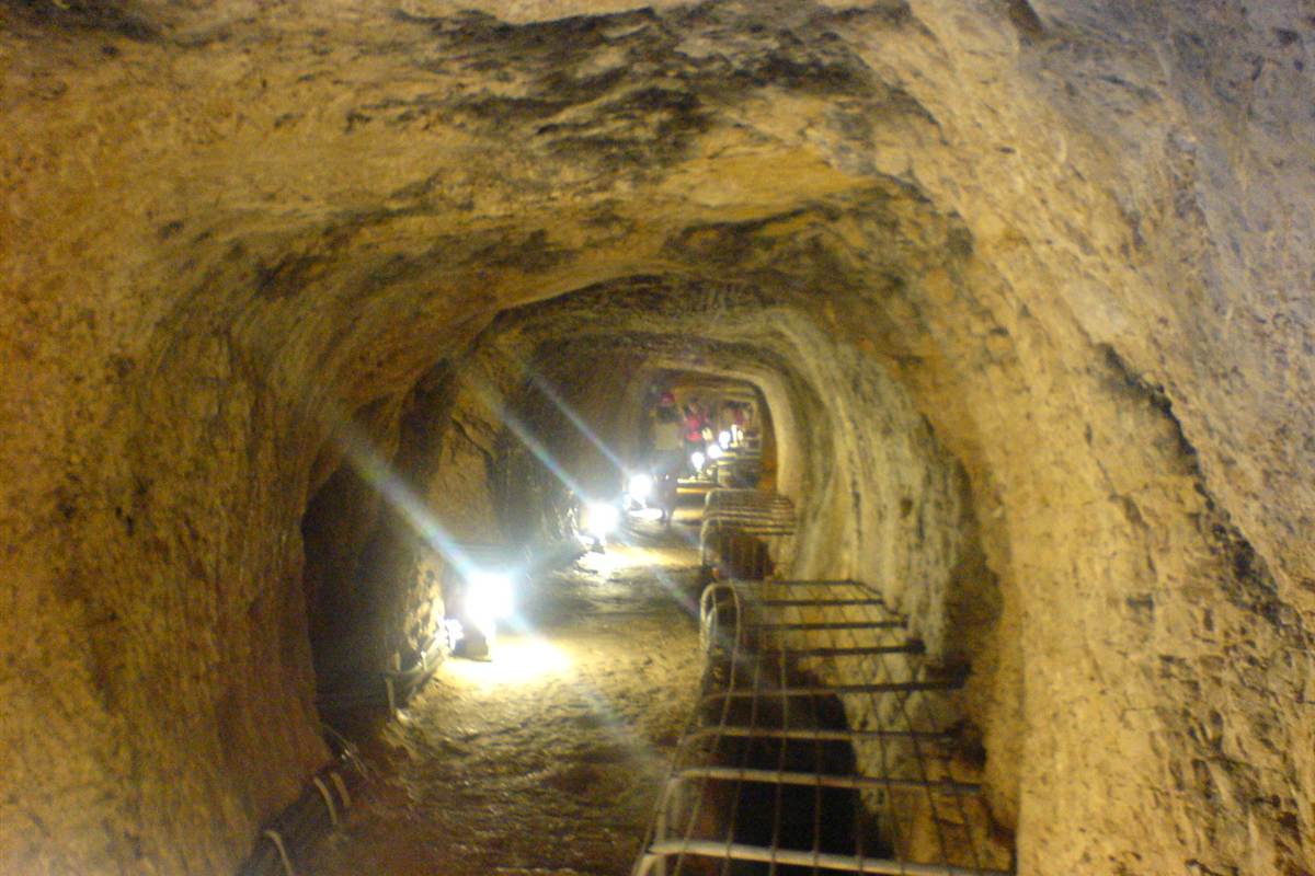
The Tunnel of Eupalinos belongs to the same site. It runs 1,036 metres through Mount Kastro and carried water to the ancient town. Two teams under the engineer Eupalinos dug it from both ends in the mid-sixth century B.C. Herodotus counted it among three great engineering feats of the Samians. Portions of the tunnel are open to the public.
Samos tours also reach the Heraion, a vast sanctuary of Hera. The site sits on low, marshy ground by the Imbrasos river, 6 kilometres southwest of the old city. Signs of worship on the spot reach back to about 1,700 B.C. The late Archaic temple was the first of the gigantic free-standing Ionic temples.
Herodotus called it the largest temple known to him. The Great Temple measured 55.2 by 108.6 metres, one of the largest floor plans of any Greek temple. It was never wholly finished. The altar was rebuilt seven times. In Byzantine times the site served as a quarry, so only the foundations and one column shaft remain.
The Sacred Way linked the sanctuary to the city of Samos by land. Builders first laid it out around 600 B.C. and repaved it in the third century A.D. An earthen dam carried it over the river. The stone slabs of that repaving are visible today. Among Samos tours, one listing pairs the Heraion with the village of Potami.
Which beaches do Samos tours stop at?
Samos tours stop at sand and pebble beaches all around the island’s coast. Potami and Megalo Seitani lie on the north coast, and Psili Ammos on the southeast coast. The islet of Samiopoula has a beach of its own.
Kokkari has a small harbour at one end of its peninsula and a pebble beach at the other end. Close by lie more pebble beaches, among them Lemonakia and Tsamadou. Both run about 400 metres, and a path of about 200 metres leads to each. Tsamadou has turquoise water that deepens abruptly. Kokkari’s own beach has deep, clear water.
On Samos tours of the north coast, Potami beach lies 2 kilometres past the port of Karlovasi. It stretches 800 metres, with fine pebbles and crystal clear water. Wikipedia names the Potami waterfalls and the nearby Seitani beaches as popular attractions of the island. Northern winds raise high waves there. A beach bar, a cafe and a restaurant stand nearby.
Mikro Seitani is a small pebble beach of 150 metres, with deep and clear water. Megalo Seitani is 350 metres long, with thick sand and deep water. A trail of another 2 kilometres runs on from Mikro to Megalo Seitani. Wikivoyage also lists a daily boat excursion to Megalo Seitani from the port of Karlovasi.
Samos tours along the southeast coast reach Psili Ammos, about 9 kilometres south of Vathy. Wikivoyage gives a length of about 200 metres, with very fine sand and very shallow, clear water. The beach is well protected from the winds. On the southwest coast, Votsalakia is a 3-kilometre beach of sand and pebbles in the bay of Marathokampos.
Samiopoula is an islet 0.85 kilometres south of Samos. Wikipedia says daily excursions run in the tourist season from Pythagoreio and Ormos Marathokampou. Its only beach, Psalida, is small, with white sands and turquoise waters. Wild goats outnumber its inhabitants. One listing gives its boat cruise as four to eight hours, and another sails from the Votsalakia port.
What do Samos tours show in the villages and on Mount Kerkis?
Samos tours show hill villages such as Vourliotes and Manolates, the towns of Vathy and Karlovasi, and Mount Kerkis. This mountain of whitish marble fills the west of the island. Its summit is the highest point on Samos.
Wikipedia gives the highest peak of Kerkis, called Vigla, a height of 1,433 metres. That makes it the second-highest peak in the East Aegean, after Fengari on Samothrace. The marble shows as white stone on exposed cliffs. The article adds that the mountain belongs to a European Union network of protected sites.
Small monasteries stand on its slopes, along with a number of caves. The article names the Cave of Pythagoras, on the eastern slope, as the notable one. Pythagoras is reputed to have hidden there from the tyrant Polycrates. One local operator lists hiking, rock climbing and canyoning among its Samos tours.
A local tourism site places Vourliotes in the north of the island, at 330 metres. People from Vourla, a village in Asia Minor, built Vourliotes in the late sixteenth century. The Vronta monastery stands two kilometres south-east of it. Manolates, at 360 metres, is named for the Manolas family, first to settle there in the late eighteenth century.
Among Samos tours on foot, one listing describes a day hike in Nightingale Valley to Manolates village. The listing gives its length as four to eight hours. Kokkari is a fishing harbour on a small peninsula, about 10 kilometres from the capital. Travellers can read about places to stay under hotels on Samos.
Wikipedia calls Karlovasi, on the northwest side, the island’s commercial centre. Vathy, the capital, has an Archaeological Museum that shows finds from the Heraion site. A local tourism site lists a colossal kouros among the exhibits, almost 5.50 metres high. Travellers who drive between villages on Samos tours can read about car hire.
How do Samos tours combine Patmos, Ikaria and Ephesus?
Samos tours add Patmos and Ephesus as day trips: tour listings give each more than eight hours. Wikipedia places the island of Ikaria 10 nautical miles, or 19 kilometres, southwest of Samos.
Among Samos tours, one listing names a Patmos day trip with the Cave of the Apocalypse, Chora and a monastery. Wikipedia says Chora, the monastery and the cave hold UNESCO World Heritage status. The article lists regular ferry services that connect Patmos to Pythagoreio and Karlovassi on Samos, and to Naxos.
Agios Kirykos and Evdilos are the only two ports of Ikaria served by passenger ferries, says Wikipedia. Fournoi is a small archipelago between Ikaria, Samos and Patmos. Boats link it with Ikaria and Samos outside winter, Wikipedia says. The Fournoi article adds that a ferry from Samos to Athens also stops at Ikaria and Paros.
Two listings among Samos tours cover Turkey: a Kusadasi day trip by ferry and an Ephesus day tour from Samos. Kusadasi, in Aydin Province, lives mainly from tourism and lies 95 kilometres south of Izmir. Its Wikipedia article says Samos lies about 16 kilometres offshore. Another article names a port link between Karlovasi and Sigacik, also in Turkey.
Greek colonists founded Ephesus in the tenth century B.C. on the coast of Ionia. A theatre for 24,000 spectators and the Library of Celsus stood among its monumental buildings. Close by stood the Temple of Artemis, counted as an ancient wonder. The ruins now hold UNESCO World Heritage status, and the resort town of Kusadasi gives access, Wikipedia says.
The Cyclades, a group of the Aegean, hold about 220 islands in Wikipedia’s count. The group is named for the islands that circle Delos, an island holy to the ancient Greeks. The largest is Naxos, and the article names Mykonos among the major islands. The Ikaria article places the Cyclades west of Ikaria and far south of it.
What else do travellers ask about Samos tours?
Which thinkers were born on the island that Samos tours visit?
Herodotus and Isocrates agree that Pythagoras was born on Samos, Wikipedia reports. The article dates his life to about 570 to 495 B.C. The Pythagorean theorem is named after him, and he is the founder of Pythagoreanism.
Epicurus was born in the Athenian settlement on Samos in February 341 B.C. He later founded a school called The Garden in Athens. Aristarchus, born on Samos around 310 B.C., presented the first known model with the Sun at the centre. Samos tours run on the home island of all three.
What do the old name of the island and the goddess Hera add to Samos tours?
Wikipedia says Strabo derived the name Samos from a Phoenician word meaning high. Its Hera article adds that the island bore the name Parthenia in the Carian period.
The same article says Hera was originally a goddess of fertility in the Toneia, a Samian festival. At the start, an image of the goddess was carried on a plank to the sea. It was then brought back to the coast. At Samos, Hera’s plank was tied on a willow tree to ensure fertility.
What is the Samian wine behind the wine tastings on Samos tours?
Wikipedia says the wine of ancient Samos was well known, and the island still produces it. Classical Samos was renowned for its wines and its red pottery. The Romans called that pottery Samian ware.
Vineyards cover a great part of Samos, and they yield Muscat wine. The Muscat grape is the main crop used for wine production. The Muscat article names the variety Muscat blanc à Petits Grains. Nearly all the notable sweet Muscats of Greece, particularly those from Samos, are made from it.
What is a Pythagorean cup, and how does it relate to Samos tours?
Wikipedia calls a Pythagorean cup a practical joke device in the form of a drinking cup. When it is filled beyond a certain point, a siphoning effect drains the whole contents through the base. The cup has been used to make statements about greed.
Hero of Alexandria described a similar vessel in the first century. The earliest such cup known to survive is a silver Roman example from the late fourth century. A recent folk tradition connects the cup’s design to Pythagoras, who was born on Samos.
What is the weather like for Samos tours?
Wikipedia classes the climate of Samos as Mediterranean, type Csa. Rain falls in mild winters, and the summer months are hot and dry. The hottest, driest month is July, and August comes next. February is the coldest month, and December records the highest rainfall. The island receives about 705 millimetres of rain a year.
Greeks also call the Etesian winds meltemia. They are dry, strong winds from the north that sweep the Aegean. Wikipedia records their peak in July and August. It calls them dangerous to sailors, which matters for the boat cruises among Samos tours. For help with dates, ask us about a trip to Samos.